

A Travel Guide to the Icelandic Highlands
The Icelandic Highlands are a region in Iceland that encompasses the central plateau. This elevated area is characterized by its stark landscapes, rugged mountains, behemoth glaciers, and volcanic activity. Inhospitable and wild, it’s where the raw power of Icelandic nature is on full display.
Visiting the Icelandic Highlands with a 4x4 campervan gives you a unique chance to disconnect from everything else and immerse yourself in wild and primordial landscapes. Despite its challenging accessibility, the Highlands are a must-visit for those looking to experience the untouched and dramatic beauty of Iceland.
Traveling by campervan provides you with the freedom and flexibility that is necessary to undertake any Highlands adventure. In this article, we will cover everything you need to know about traveling in the Icelandic Highlands with a 4x4 campervan.
What are the Icelandic Highlands?
The Icelandic Highlands is the large, uninhabited central region of Iceland. It’s called the Highlands because of the higher altitude, bringing colder and more dramatic weather. The area is vast, and aside from a handful of farms, there are no permanent settlements here since it’s inhospitable for most of the year.
Geographically speaking, the Highlands cover a huge portion of Iceland. There are various access points, all of them designated as F-roads, which means you’ll need a 4x4 to drive on them. Some of the most famous areas in the Highlands are Landmannalaugar, Thórsmörk, Askja, Kerlingarfjöll, and most of Iceland’s glaciers.

How to Get to the Highlands in a Campervan
Firstly, you’ll need a 4x4 campervan to get to the Icelandic Highlands. It’s illegal to drive any regular vehicle on F-roads since these are rough gravel roads that often need you to ford rivers.
From the capital area, the closest entrance point to the Highlands is just beyond Gullfoss Waterfall on the Golden Circle. This is the beginning of the F35 or the Kjölur Route. Another close entrance point is at the very top of the Thjórsárdalur Valley, where F-roads venture towards the Landmannalaugar area along the beginning of the Sprengisandur Route.
Travel Distance: The distance from Reykjavik to major Highland entry points varies, but it typically takes between 4 to 6 hours by car, depending on the specific destination and road conditions. For instance, reaching the start of the Kjölur route at Gullfoss is about 125 kilometers (78 miles) and takes around 2 hours. Beyond that, it’ll take another couple of hours to reach Kerlingarfjöll, a major highlight along the route.
When Do the Icelandic Highlands Open?
The F-roads remain impassable for most of the year, only opening for the summer between June and September. Due to the glacial melt in Spring, the rivers are at their strongest, and the roads are muddy and difficult to pass; driving on them would make them even rougher for the season ahead. That’s why each year, the Icelandic Road and Coastal Administration assesses the condition of the F-Roads, opening them only once it has been deemed safe enough to do so.
Most roads will open in June and sometimes early July. They then close towards the end of September. It all depends on what the weather has been doing.

The Best Time to Visit
The best time to visit the Icelandic Highlands is in the summer, as the access is closed for most of the year due to harsh weather conditions.
June
Traveling to the Icelandic Highlands in June can be an excellent choice. Roads can open during the middle of the month, so plan for a trip then or towards the end of June. The crowds have yet to arrive at the major destinations, and in some cases, you may be the first person to drive along a route for that year. The trade-off is that when booking in advance, you rely on the notoriously fickle Icelandic weather to behave and ensure the roads are open when you arrive. But if it all works out, you’re in for a real treat of an adventure.
July
By July, most of the F-roads are open, allowing unfettered access to the Highlands. This is a great time to be here, although, of course, you can expect it to be more crowded as the month goes on. There still may be snow in some places, but all hiking trails will also be available. Some of the more remote F-roads might still be closed until mid-July.
August
Traveling in the Icelandic Highlands in August is much like July: mild weather and general crowds at the most famous destinations. As the month continues, temperatures begin to drop, and bad weather can threaten plans. Still, barring any storms or heavy rains that make rivers impassable, during August, 100% of F-Roads are open and passable.
September
September offers a different kind of experience in the Highlands. The weather is moodier, and the days are getting darker, giving you the feeling of racing against the clock to explore before the roads close. The crowds of August have left, but most things remain open until at least mid-September.

How Long Do I Need for a Campervan Trip in the Highlands?
If you’re purely going to be focused on the Icelandic Highlands with your campervan, then we recommend carving out a minimum of 6 or 7 days to get a good idea of the region and visit some of the different destinations.
This amount of time allows you to visit Landmannalaugar, drive the Sprengisandur Route, visit Askja, and then drive the Kjölur Route back down to the Golden Circle area to end your trip.
Although a bit more time will always be nice, check out our sample 9-day self-drive itinerary for the Highlands.
The Best Destinations in the Icelandic Highlands
Landmannalaugar
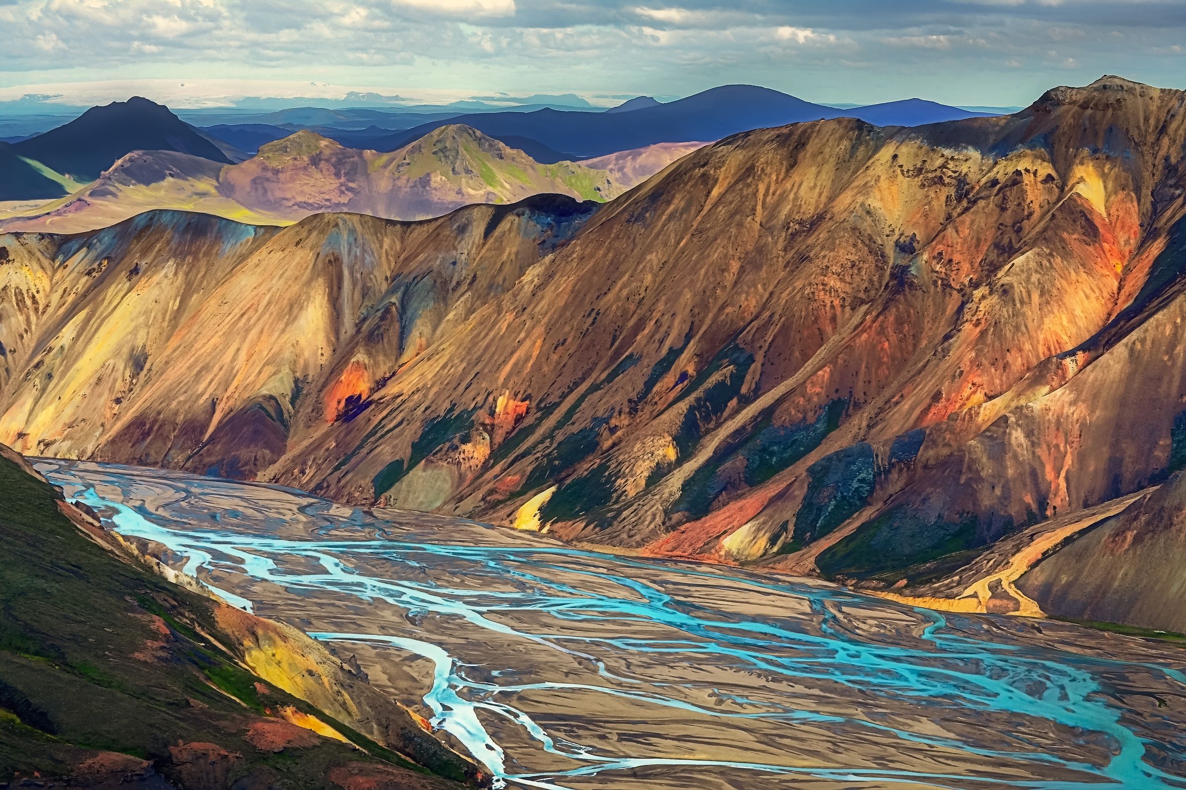
Landmannalaugar is Iceland’s renowned highland destination, celebrated for its vibrant mountains and intricate lava fields and as the starting point for the Laugavegur Trail. This area is ideal for hikers, featuring diverse landscapes such as majestic mountains, large craters, and geothermal valleys. If you’re planning a trip to the Highlands in a campervan, this should be on your itinerary.
The main attraction in Landmannalaugar is the rhyolite mountains, famous for their shifting colors. Additionally, the area offers a natural hot spring, volcanic craters, and lakes. The wider Fjallabak Reserve is also famous for its black sand desert and striking mountains covered in green moss, creating a striking contrast.
Read our detailed guide to Landmannalaugar.
- Accessing Landmannalaugar: There are three F-road routes to reach Landmannalaugar. The simplest approach is from the north via F26 and F208, which involves one river crossing just before reaching Landmannalaugar. A more challenging route is from the west along F225, involving several unpredictable river crossings. The most difficult route is from the south on F208, requiring multiple large river crossings and a long day of driving.
- Camping at Landmannalaugar: Landmannalaugar operates a large campsite, although since this is a remote destination, the facilities aren’t quite up to par with other campsites around the country.
Thórsmörk
Situated between the glaciers Tindfjallajökull and Eyjafjallajökull in southern Iceland, Thórsmörk is a lush valley featuring birch forests, striking lava rock formations, and glacial rivers meandering through black sand beds. This destination is also known for its exceptional hiking trails and is the end (or beginning) point of the Laugavegur Trek and the Fimmvörðuháls Pass.
Thórsmörk showcases Iceland’s moss, basalt, and glaciers beautifully. Hiking trails lead to ice caps, secretive canyons, and stunning landscapes where green moss contrasts with ashen basalt, creating a fairytale-like atmosphere.
- Accessing Thórsmörk: Thórsmörk is challenging to reach, requiring navigation of F249, which includes several river crossings, notably the Krossá River. This river is deep and fast, and we strongly advise against attempting to get here in your campervan, even if you’ve rented one of our larger 4x4s. Read up on how to catch the bus to Thórsmörk with this comprehensive guide to the area.
- Camping in Thórsmörk: Without a campervan, there are a few different options to consider if you’ve chosen to visit Thórsmörk. There are the mountain huts Langidalur, Húsadalur, and Básar, each offering sleeping bag accommodation. Then the Volcano Huts also have a range of accommodations on offer, from dorms to glamping tents to private mountain huts.

Kerlingarfjöll
Kerlingarfjöll is a geothermal area of mountains in Iceland's central highlands, known for its steaming hot springs, colorful mountains, and rugged terrain. This area offers plenty of surreal landscapes, including steaming vents, boiling mud pots, and stunning views into the interior from the tops of the mountains. The best place to visit within Kerlingarfjöll is Hveradalir, a beautiful area that you’ve likely already seen in photos. Often, the two names are used interchangeably to talk about this place.
Hveradalir is where you can hike through and around the mountains, using the wooden steps built into the spines of the hills. Steam wafts out of the valleys below, and as you dip down into the valleys, you’ll find yourself hiking beside boiling streams of water and colorful mineral interactions in the earth.
- Accessing Kerlingarfjöll: Reached via F35 (Kjölur Route), the drive from the Gullfoss waterfall takes 2-3 hours, offering views of glaciers, mountains, and highland deserts. There are no river crossings to reach Kerlingarfjöll.
- Camping at Kerlingarfjöll: The Highland Base at Kerlingarfjöll also has a campsite with brand new facilities as of 2024. This is a short drive back from Hveradalir.

Hveravellir
Hveravellir, a geothermal oasis located in Iceland's central highlands, is renowned for its hot springs, fumaroles, and stunning landscapes. Nestled between the Langjökull and Hofsjökull glaciers, this remote destination offers a sort of oasis in the middle of the desolate Kjölur Route, with hot springs and a restaurant.
Hveravellir features boiling mud pots, steaming vents, and vibrant hot springs in colors ranging from deep blues to striking whites. The area is crisscrossed with wooden boardwalks, allowing visitors to explore safely. One of the highlights is the natural hot spring, a perfect spot for a relaxing soak amidst the pristine highland scenery.
- Accessing Hveravellir: To reach Hveravellir, you must travel along the Kjölur Route (F35), which runs through the heart of the highlands between the Gullfoss waterfall in the south and Blönduós in the north. There are no river crossings on F35.
- Camping at Hveravellir: Like many other campsites in the Highlands, you’ll simply be parked in the large parking area of the mountain lodge here. Still, the facilities are decent, and the restaurant is good.

Askja
Askja is a remote volcanic caldera known for its desolate desert and volcanic landscapes, located north of the glacier Vatnajökull. Formed by an 1875 eruption, it features Lake Öskjuvatn, Iceland’s deepest lake, and the warm, turquoise-colored Viti crater, a famous place where you can bathe in the warm, volcanic waters that have filled the crater.
- Accessing Askja: It can be reached via F88 from the north or F905 from the northeast. Both routes require a high-clearance 4x4 vehicle. F88 has a river crossing that can become impassable after rainfall. The west route via F910 is also difficult, involving challenging terrain and river crossings, although the rivers on F88 aren’t known to swell like the one on F905.
- Camping at Askja: With your 4x4 campervan, you can choose to spend the night camping outside of the Dreki Mountain Hut. Also, in the area (but still a few hours in your camper) is Möðrudalur, a remote farm in the northeastern Highlands where you can camp.

Herðubreiðarlindir
Herðubreiðarlindir, a lush oasis located at the foot of Herðubreið, Iceland's "Queen of Mountains," is a striking contrast to the surrounding desolate highlands. This verdant area is famed for its crystal-clear springs, vibrant vegetation, and historical significance, offering a serene escape amidst the stark volcanic landscapes of the Ódáðahraun lava field.
Herðubreiðarlindir is characterized by its numerous freshwater springs that bubble up from beneath the lava, creating small streams and pools surrounded by rich greenery. The clear waters and lush grasses make it a haven for local birdlife.
- Accessing Herðubreiðarlindir: Reaching Herðubreiðarlindir involves traveling along the F88 route, which branches off from the main ring road near Myvatn and leads through the remote highlands. This road requires a 4x4 vehicle due to rough terrain and unpredictable river crossings.
- Camping at Herðubreiðarlindir: Campervans can stay at the campsite Þorsteinsskáli.

Snæfell
Snæfell, Iceland’s highest freestanding mountain, offers spectacular views of the eastern highlands near Vatnajökull glacier. This is a remote area of the Highlands, furthest from Reykjavik, and likely one of the least-visited areas of the country. It only recently became accessible, so it still feels like a pristine wilderness.
- Accessing Snæfell: Reached via F909, a capable 4x4 vehicle is necessary due to several river crossings. The route provides a dramatic entrance to the eastern highlands and continues past Snæfell to the northern edge of Vatnajökull glacier.
- Camping at Snæfell: The Snæfellsskáli Mountain Hut, located at the mountain’s base, is where you can camp with your 4x4 campervan.

Lakagígar
The Laki Craters, formed by a massive 1783 eruption, showcase Iceland’s volcanic power with craters, lava fields, and moss-covered landscapes. The eruption caused widespread famine across Europe, one of the sparks that ignited the French Revolution.
The 29 km-long crater row is covered in moss and offers plenty of swoon-worthy Icelandic scenery. Black sand, green moss, glacial lakes, nearby ice caps, and hardly any other people all make this one of the more arresting destinations to visit in the Icelandic Highlands.
- Accessing Lakagígar: Navigating F206 and F207 requires a sturdy 4x4 vehicle due to rough terrain and river crossings. The journey offers spectacular views but is challenging, requiring experienced drivers.
- Camping at Lakagígar: Blágil campsite provides the bare minimum for a campsite: remote, quiet, and beautiful.

Eldgjá & Langisjór
Eldgjá and Langisjór are remote highland destinations west of the Vatnajökull glacier. Eldgjá, a giant volcanic fissure created by the 10th-century Katla eruption, offers impressive hiking through its canyon, highlighted by the Ófærufoss waterfall.
North of Eldgjá, Langisjór is a pristine lake surrounded by moss-covered mountains, glacial ice, and black sand, creating a striking landscape. As with most destinations in the Highlands, it’s all about hiking at both destinations.
- Accessing Eldgjá and Langisjór: Eldgjá is accessed via F208 from the ring road, continuing to Langisjór via F235. Both routes are challenging, offering some of the best scenery in the highlands.
- Camping at Eldgjá and Langisjór: Near Eldgjá, the Hólaskjól Highland Center offers a basic campsite with access to their facilities. For a more remote and wild experience, you can also choose to camp at Langisjór, where a remote campsite with minimal facilities is right next to the lake.


Mælifell Mountain
Mælifell Mountain, a striking volcanic cone located in the southern highlands of Iceland, is renowned for its symmetrical shape, vibrant green moss covering, and dramatic surroundings. This isolated peak rises prominently from the black sand plains of the Mýrdalsjökull glacier, creating a surreal and otherworldly landscape.
Mælifell's distinctive green color results from the moss that thrives on the volcanic ash, creating a stunning contrast against the dark, barren plains and the nearby glacier. This pristine and untouched area feels like a journey into another world. The mountain stands at about 200 meters (656 feet) tall, and its perfect cone shape adds to its allure, making it a popular subject for landscape photography.
- Accessing Mælifell: Reaching Mælifell requires a journey along F210, a challenging highland road. The drive to Mælifell offers breathtaking views of glaciers, volcanic deserts, and highland landscapes.
- Accommodation Options: Due to its remote location, there are no accommodation facilities directly at Mælifell. However, nearby highland huts Álftavatn and Hvanngil offer small areas where you can park your campervan for the night while exploring.

Driving on the Icelandic F-Roads
Driving on these mountain roads is no easy feat. You’ll need a robust 4x4 campervan, and the confidence to ford rivers with it.
We’ve written a detailed article about driving on Iceland’s F-Roads to help you prepare for a trip to the Highlands.

Conclusion
Exploring the Icelandic Highlands in a 4x4 campervan is such an epic experience. The landscapes are wild, and it feels like you’re stepping onto another planet. Whether you’re hiking colorful mountains in Landmannalaugar or soaking in hot springs at Hveravellir, it’s all about the freedom to explore at your own pace. Just make sure you’re ready for rough roads, river crossings, and no cell service—it’s all part of the adventure!